In Aireon’s blog series, ‘Back-to-Basics’, 1090 Global is breaking down the complexity of the AireonSM system into simpler terms. Though they know that not everyone is a satellite engineer or an air traffic controller, they can assure us that it is not all rocket science! We are sharing their series because it helps us raise awareness on aviation safety and highlights an example of the technologies that help to support international air connectivity. This is the first of Aireon’s two part series.
When you operate in a world filled with acronyms and highly technical terms, it can sometimes feel like you are diving into a big bowl of alphabet soup. We know that in order to fully understand Aireon, it’s helpful to understand the “jargon” that comes with the industry. With that in mind, we have compiled a beginner’s guide to the Aireon system, Iridium® NEXT satellites, ADS-B and more. You are welcome to keep this guide handy in the event you need clarity on the many acronyms and terms we use on a daily basis.
Below you will find several of the most commonly used acronyms and terms when reading and speaking about Aireon and the aviation world in general. The following guide only scratches the surface but should provide a solid foundation.
Aireon Network & Infrastructure Acronyms & Terms:
- ADS-B = Automatic Dependent Surveillance-Broadcast
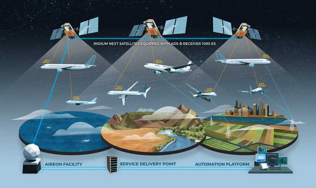
ADS-B is a surveillance technique that relies on aircraft broadcasting their identity, a precise GPS position, altitude and velocity. The signal is broadcast through line-fit antennas that send the information every second. It is “automatic” because no work is required from the pilot or Air Traffic Controller to broadcast the signal. It is dependent because it relies on on-board avionics to provide surveillance information to other parties.
- Space-Based ADS-B = Space-Based Automatic Dependent Surveillance-Broadcast
Aireon will provide the first global air traffic surveillance system using a space-based ADS-B network that makes it possible to extend visibility across the entire planet. Essentially, rather than relying on ground-based infrastructure to track aircraft, Aireon is taking that capability to space by placing its technology (ADS-B receivers) on board the only truly global satellite constellation, Iridium NEXT. These receivers will relay signals from all ADS-B equipped aircraft to controllers worldwide. Since this is a space-based network and requires no local, ground-based infrastructure, Aireon will deliver the first ever technology that can provide on-going tracking of aircraft over oceans in real-time, and the 80+ percent of the world’s Flight Information Regions (FIRs) currently not covered by any real-time surveillance.
- LEO = Low Earth Orbit
Iridium NEXT, the constellation hosting the above-mentioned Aireon ADS-B receivers, is located in low Earth orbit. As indicated by its name, this orbit is in closer proximity to Earth than other orbits, such as geostationary orbits. The Iridium NEXT constellation is approximately 483 miles above earth. The LEO altitude allows aircraft ADS-B signals to be received in space without any additional equipment or changes to existing aircraft avionics. It also allows for a shorter transmission path, strong signals and lower latency.
- SV = Satellite Vehicle (or in other contexts, Space Vehicle)
Each individual satellite within the Iridium NEXT constellation is referred to as an SV (satellite vehicle). 66 SVs make up the operational constellation.
- Crosslinks = Unique to the Iridium NEXT constellation architecture
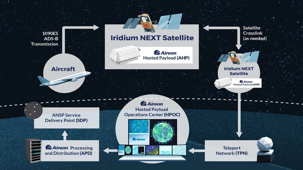
Each Iridium NEXT satellite is linked to its surrounding Iridium satellites – in front, behind, to the left and the right – creating a dynamic meshed network that routes traffic through each other. This is made possible through its crosslinks (picture the satellites holding hands with each other and following their own “buddy system”).

Technical Overview Acronyms & Terms:
- AHP = Aireon Hosted Payload
Since Aireon’s technology is hitching a ride to LEO on every Iridium NEXT satellite, the technical term for this relationship is a “hosted payload”. The Aireon technology is the payload, which is being hosted on each Iridium NEXT satellite. Each AHP transfers aircraft data from satellite to satellite down to Iridium’s Teleport Network (TPN) and Aireon Processing Distribution (APD) system.
- TPN = Teleport Network
This is the first stop on earth for Aireon data. It’s the transfer point between the AHP and the Hosted Payload Operations Center (see below).
- HPOC = Hosted Payload Operations Center
This is where the health and status of the AHPs are monitored. Command and control operations take place here as well, including the delivery of mission data to Aireon Processing and Distribution (see below).
- APD = Aireon Processing and Distribution
Once the data arrives here from the HPOC, it is decoded and verified before being delivered to its appropriate stakeholder facility that has subscribed to the Aireon service.
- ANOC = Aireon Network Operations Center
Working in tandem with APD, the ANOC delivers ADS-B reports to subscribers, monitoring major system applications and assets, and monitors and compiles key payload performance data.
- SDP = Service Delivery Point
This is the demarcation point of Aireon’s data – where the data reaches the end customer’s service point.
- SNOC = Satellite Network Operations Center
This is the Iridium facility where the satellite network command and control efforts take place, as well as where health monitoring and performance testing and validation processes occur. It is also the location of Aireon’s HPOC.

Industry Organization Acronyms:
- ANSP = Air Navigation Service Provider
ANSPs are organizations that manage air traffic on behalf of a region or country. Not all ANSPs are alike, but they all are responsible for providing Air Navigation Services, including air traffic management, search and rescue surveillance and more to its designated region of operation. In relation to Aireon, ANSPs are all potential customers of Aireon. The data delivered by the Aireon system has the potential to vastly improve their operational efficiency, increase safety and effectiveness without requiring significant new infrastructure investment on the part of the ANSP.
- FIR = Flight Information Region
A FIR is a specified region of airspace that provides flight information and alerting services. FIRs are managed by ANSPs and provide clear borders and boundaries for airspace control and organization.
- ICAO = International Civil Aviation Organization
A United Nations specialized agency that was founded in 1944 to manage the administration and governance of the Convention of International Civil Aviation (Chicago Convention). Today, ICAO works with the Convention’s 192 Member States and industry groups to reach consensus on international civil aviation Standards and Recommended Practices (SARPs) and policies in support of a safe, efficient, secure, economically sustainable and environmentally responsible civil aviation sector (source: www.ICAO.int).
Solutions & Services:
- GADSS = Global Aeronautical Distress & Safety System
A system created by ICAO in response to the loss of flights AF447 and MH370. GADSS contains Standards and Recommended Practices (SARPS) that establish what is expected of airlines and aircraft operators for tracking aircraft in normal conditions as well when an aircraft is in distress. Normal aircraft tracking SARPs are applicable starting November 2018 and establish the air operator’s responsibility to track its aircraft throughout its area of operations. Operators are expected to receive positions at least once every 15 minutes. The SARPs relating to the location of an aircraft in distress become applicable in January 2021 and establish the requirement for automatically tracking aircraft in distress with position updates at least once-per-minute. In both of these instances, Aireon will play a critical role in ensuring GADSS SARPS are effectively implemented (source: www.globalbeacon.com)
- GlobalBeaconSM
Powered by Aireon and FlightAware (see below) GlobalBeacon is a web-based alerting dashboard that provides 100-percent global, real-time aircraft tracking, with minute-by-minute position updates. It is a direct response to GADSS, and leverages Aireon’s position data with FlightAware’s web interface to provide a solution that gives airlines and aircraft operators the peace of mind that their fleet is being monitoring anywhere in the world, and able to receive immediate notification of when an aircraft is in distress. (source: www.globalbeacon.com)
- FlightAware
FlightAware is the world’s largest flight tracking data company that leverages data from ATC systems in over 55 countries, Aireon’s data and its own network of ADS-B ground stations to offer flight tracking services and a range of products for the aviation industry. (source: www.flightaware.com)
- Aireon ALERT = Aircraft Locating and Emergency Response Tracking
This will be the industry’s first and only free global, real-time emergency aircraft location service. ANSPs, aircraft operators, regulators and search and rescue organizations in need of crucial aircraft location data, can rely on Aireon ALERT to help provide an aircraft’s most recently known position. It will fill a critical need, ensuring search and rescue personnel have the most accurate aircraft position data available when responding to an incident, regardless of global location. The service will utilize Aireon’s space-based ADS-B data and will be operated by the Irish Aviation Authority (IAA).

